NOAA Weather Radio Station

WXM28 162.400 Sioux Falls, SD

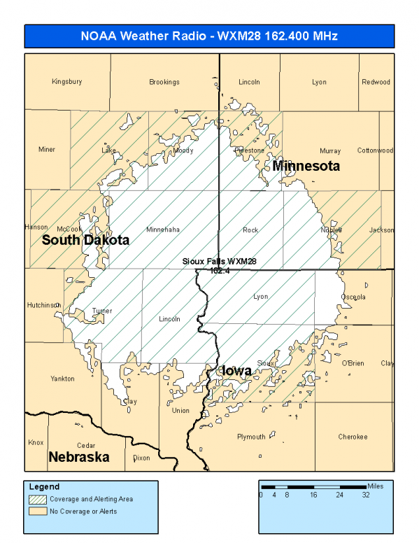
This radio station is licensed by the FCC to The National Weather Service for Sioux Falls, SD and serving the following areas:


Lyon County, IA Sioux County, IA Nobles County, MN Pipestone County, MN Rock County, MN Lake County, SD Lincoln County, SD McCook County, SD Minnehaha County, SD Moody County, SD Turner County, SD


WXM28 can be heard online using the Radio Station Net Player.
Stream Status
Verifying WXM28 Audio Stream ...
Server: Icecast 2.3.2-kh32 Encoding: audio/mpeg Bitrate: 16
Antenna Location: LAT: 43.5186647 ~ LON: -96.5348375
Loading Main Map for ...
NOAA Weather Radio WXM28 S.A.M.E. Code(s):
S.A.M.E.CountyState
019119LyonIA
019167SiouxIA
027105NoblesMN
027117PipestoneMN
027133RockMN
046079LakeSD
046083LincolnSD
046087McCookSD
046099MinnehahaSD
046101MoodySD
046125TurnerSD
WXM28 Coverage Map
Service Frequency Power Latitide Longitude
NOAA Weather RadioWeather162.400 MHz1000 Watts43.5186647-96.5348375

[ Top of Page ]

"WXM28 (162.400) Sioux Falls, SD - NOAA Weather Radio"

Radio Station:

Email: support@ | facebook | twitter
Policies: Terms & Conditions (EULA) | Privacy Policy | Cookies | DMCA

Copyright © 2025 Radio Station Network (RSN)

Station Image
Status
0:00
10
7
5
31Hz
62Hz
125kHz
250kHz
500kHz
1kHz
2kHz
4kHz
8kHz
15kHz
VOL.