NOAA Weather Radio Station

WNG588 162.500 Mount Jefferson, NC

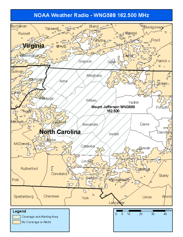
This radio station is licensed by the FCC to The National Weather Service for Mount Jefferson, NC and serving the following areas:


Alexander County, NC Alleghany County, NC Ashe County, NC Caldwell County, NC Catawba County, NC Iredell County, NC Watauga County, NC Wilkes County, NC Johnson County, TN Grayson County, VA Washington County, VA

We are not aware of any currently available online broadcast streams for this station.
Antenna Location: LAT: 36.4032369 ~ LON: -81.4634728
Loading Main Map for ...
NOAA Weather Radio WNG588 S.A.M.E. Code(s):
S.A.M.E.CountyState
037003AlexanderNC
037005AlleghanyNC
037009AsheNC
037027CaldwellNC
037035CatawbaNC
037097IredellNC
037189WataugaNC
037193WilkesNC
047091JohnsonTN
051077GraysonVA
051191WashingtonVA
WNG588 Coverage Map
Service Frequency Power Latitide Longitude
NOAA Weather RadioWeather162.500 MHz300 Watts36.4032369-81.4634728

[ Top of Page ]

"WNG588 (162.500) Mount Jefferson, NC - NOAA Weather Radio"

Radio Station:

Email: support@ | facebook | twitter
Policies: Terms & Conditions (EULA) | Privacy Policy | Cookies | DMCA

Copyright © 2025 Radio Station Network (RSN)

Station Image
Status
0:00
10
7
5
31Hz
62Hz
125kHz
250kHz
500kHz
1kHz
2kHz
4kHz
8kHz
15kHz
VOL.