NOAA Weather Radio Station

WXM42 162.475 Hagerstown, MD

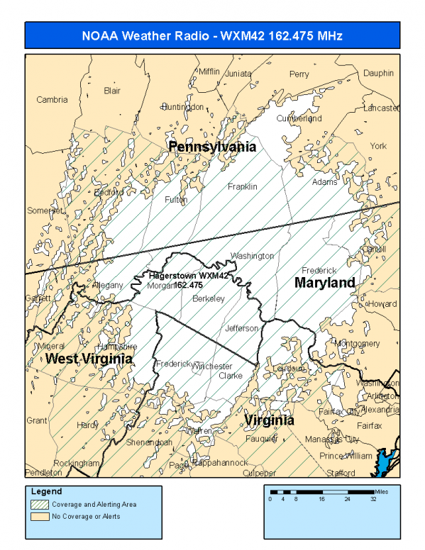
This radio station is licensed by the FCC to The National Weather Service for Hagerstown, MD and serving the following areas:


Allegany County, MD Carroll County, MD Frederick County, MD Washington County, MD Adams County, PA Bedford County, PA Franklin County, PA Fulton County, PA Clarke County, VA Fauquier County, VA Frederick County, VA Loudoun County, VA Page County, VA Shenandoah County, VA Warren County, VA Winchester City, VA Berkeley County, WV Hampshire County, WV Hardy County, WV Jefferson County, WV Mineral County, WV Morgan County, WV

We are not aware of any currently available online broadcast streams for this station.
Antenna Location: LAT: 39.6509547 ~ LON: -77.9705822
Loading Main Map for ...
NOAA Weather Radio WXM42 S.A.M.E. Code(s):
S.A.M.E.CountyState
024001AlleganyMD
024013CarrollMD
024021FrederickMD
024043WashingtonMD
042001AdamsPA
042009BedfordPA
042055FranklinPA
042057FultonPA
051043ClarkeVA
051061FauquierVA
051069FrederickVA
051107LoudounVA
051139PageVA
051171ShenandoahVA
051187WarrenVA
051840Winchester CityVA
054003BerkeleyWV
054027HampshireWV
054031HardyWV
054037JeffersonWV
054057MineralWV
054065MorganWV
WXM42 Coverage Map
Service Frequency Power Latitide Longitude
NOAA Weather RadioWeather162.475 MHz1000 Watts39.6509547-77.9705822

[ Top of Page ]

"WXM42 (162.475) Hagerstown, MD - NOAA Weather Radio"

Radio Station:

Email: support@ | facebook | twitter
Policies: Terms & Conditions (EULA) | Privacy Policy | Cookies | DMCA

Copyright © 2025 Radio Station Network (RSN)

Station Image
Status
0:00
10
7
5
31Hz
62Hz
125kHz
250kHz
500kHz
1kHz
2kHz
4kHz
8kHz
15kHz
VOL.