NOAA Weather Radio Station

KIH44 162.550 Somerset, KY

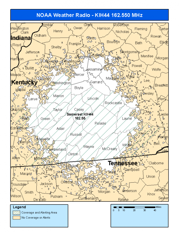
This radio station is licensed by the FCC to The National Weather Service for Somerset, KY and serving the following areas:


Adair County, KY Casey County, KY Clinton County, KY Cumberland County, KY Green County, KY Hart County, KY Knox County, KY Laurel County, KY Lincoln County, KY Marion County, KY McCreary County, KY Metcalfe County, KY Monroe County, KY Pulaski County, KY Rockcastle County, KY Russell County, KY Taylor County, KY Washington County, KY Wayne County, KY Whitley County, KY


KIH44 can be heard online using the Radio Station Net Player.
Stream Status
Verifying KIH44 Audio Stream ...
Antenna Location: LAT: 37.1674130 ~ LON: -84.8249567
Loading Main Map for ...
NOAA Weather Radio KIH44 S.A.M.E. Code(s):
S.A.M.E.CountyState
021001AdairKY
021045CaseyKY
021053ClintonKY
021057CumberlandKY
021087GreenKY
021099HartKY
021121KnoxKY
021125LaurelKY
021137LincolnKY
021155MarionKY
021147McCrearyKY
021169MetcalfeKY
021171MonroeKY
021199PulaskiKY
021203RockcastleKY
021207RussellKY
021217TaylorKY
021229WashingtonKY
021231WayneKY
021235WhitleyKY
KIH44 Coverage Map
Service Frequency Power Latitide Longitude
NOAA Weather RadioWeather162.550 MHz1000 Watts37.1674130-84.8249567

[ Top of Page ]

"KIH44 (162.550) Somerset, KY - NOAA Weather Radio"

Radio Station:

Email: support@ | facebook | twitter
Policies: Terms & Conditions (EULA) | Privacy Policy | Cookies | DMCA

Copyright © 2025 Radio Station Network (RSN)

Station Image
Status
0:00
10
7
5
31Hz
62Hz
125kHz
250kHz
500kHz
1kHz
2kHz
4kHz
8kHz
15kHz
VOL.