NOAA Weather Radio Station

KIH41 162.400 Lexington, KY

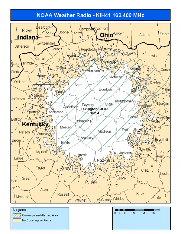
This radio station is licensed by the FCC to The National Weather Service for Lexington, KY and serving the following areas:


Anderson County, KY Bath County, KY Bourbon County, KY Boyle County, KY Clark County, KY Estill County, KY Fayette County, KY Fleming County, KY Franklin County, KY Garrard County, KY Harrison County, KY Jessamine County, KY Madison County, KY Menifee County, KY Mercer County, KY Montgomery County, KY Nicholas County, KY Powell County, KY Robertson County, KY Rowan County, KY Scott County, KY Woodford County, KY

We are not aware of any currently available online broadcast streams for this station.
Antenna Location: LAT: 37.8791724 ~ LON: -84.3259209
Loading Main Map for ...
NOAA Weather Radio KIH41 S.A.M.E. Code(s):
S.A.M.E.CountyState
021005AndersonKY
021011BathKY
021017BourbonKY
021021BoyleKY
021049ClarkKY
021065EstillKY
021067FayetteKY
021069FlemingKY
021073FranklinKY
021079GarrardKY
021097HarrisonKY
021113JessamineKY
021151MadisonKY
021165MenifeeKY
021167MercerKY
021173MontgomeryKY
021181NicholasKY
021197PowellKY
021201RobertsonKY
021205RowanKY
021209ScottKY
021239WoodfordKY
KIH41 Coverage Map
Service Frequency Power Latitide Longitude
NOAA Weather RadioWeather162.400 MHz1000 Watts37.8791724-84.3259209

[ Top of Page ]

"KIH41 (162.400) Lexington, KY - NOAA Weather Radio"

Radio Station:

Email: support@ | facebook | twitter
Policies: Terms & Conditions (EULA) | Privacy Policy | Cookies | DMCA

Copyright © 2025 Radio Station Network (RSN)

Station Image
Status
0:00
10
7
5
31Hz
62Hz
125kHz
250kHz
500kHz
1kHz
2kHz
4kHz
8kHz
15kHz
VOL.