NOAA Weather Radio Station

KIH40 162.475 Hazard, KY

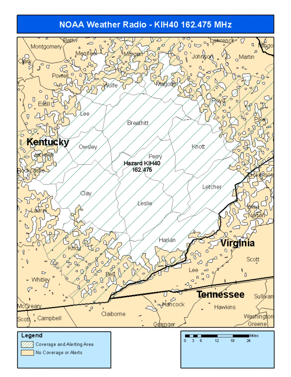
This radio station is licensed by the FCC to The National Weather Service for Hazard, KY and serving the following areas:


Bell County, KY Breathitt County, KY Clay County, KY Floyd County, KY Harlan County, KY Jackson County, KY Knott County, KY Knox County, KY Lee County, KY Leslie County, KY Letcher County, KY Magoffin County, KY Morgan County, KY Owsley County, KY Perry County, KY Pike County, KY Wolfe County, KY

We are not aware of any currently available online broadcast streams for this station.
Antenna Location: LAT: 37.1928008 ~ LON: -83.1879294
Loading Main Map for ...
NOAA Weather Radio KIH40 S.A.M.E. Code(s):
S.A.M.E.CountyState
021013BellKY
021025BreathittKY
021051ClayKY
021071FloydKY
021095HarlanKY
021109JacksonKY
021119KnottKY
021121KnoxKY
021129LeeKY
021131LeslieKY
021133LetcherKY
021153MagoffinKY
021175MorganKY
021189OwsleyKY
021193PerryKY
021195PikeKY
021237WolfeKY
KIH40 Coverage Map
Service Frequency Power Latitide Longitude
NOAA Weather RadioWeather162.475 MHz1000 Watts37.1928008-83.1879294

[ Top of Page ]

"KIH40 (162.475) Hazard, KY - NOAA Weather Radio"

Radio Station:

Email: support@ | facebook | twitter
Policies: Terms & Conditions (EULA) | Privacy Policy | Cookies | DMCA

Copyright © 2025 Radio Station Network (RSN)

Station Image
Status
0:00
10
7
5
31Hz
62Hz
125kHz
250kHz
500kHz
1kHz
2kHz
4kHz
8kHz
15kHz
VOL.