NOAA Weather Radio Station

WXK74 162.475 Monticello/Lafayette, IN

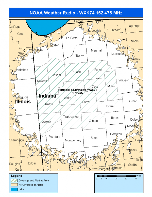
This radio station is licensed by the FCC to The National Weather Service for Monticello/Lafayette, IN and serving the following areas:


Benton County, IN Carroll County, IN Cass County, IN Clinton County, IN Fulton County, IN Howard County, IN Jasper County, IN Miami County, IN Newton County, IN Pulaski County, IN Tippecanoe County, IN Warren County, IN White County, IN

We are not aware of any currently available online broadcast streams for this station.
Antenna Location: LAT: 40.6690428 ~ LON: -86.6956660
Loading Main Map for ...
NOAA Weather Radio WXK74 S.A.M.E. Code(s):
S.A.M.E.CountyState
018007BentonIN
018015CarrollIN
018017CassIN
018023ClintonIN
018049FultonIN
018067HowardIN
018073JasperIN
018103MiamiIN
018111NewtonIN
018131PulaskiIN
018157TippecanoeIN
018171WarrenIN
018181WhiteIN
WXK74 Coverage Map
Service Frequency Power Latitide Longitude
NOAA Weather RadioWeather162.475 MHz1000 Watts40.6690428-86.6956660

[ Top of Page ]

"WXK74 (162.475) Monticello/Lafayette, IN - NOAA Weather Radio"

Radio Station:

Email: support@ | facebook | twitter
Copyright © 2025 Radio Station Info All Rights Reserved.
Station Image
Status
0:00
10
7
5
31Hz
62Hz
125kHz
250kHz
500kHz
1kHz
2kHz
4kHz
8kHz
15kHz
VOL.