NOAA Weather Radio Station

KIH43 162.475 New Albany, IN

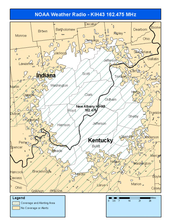
This radio station is licensed by the FCC to The National Weather Service for New Albany, IN and serving the following areas:


Clark County, IN Crawford County, IN Dubois County, IN Floyd County, IN Harrison County, IN Jefferson County, IN Orange County, IN Scott County, IN Washington County, IN Bullitt County, KY Hardin County, KY Henry County, KY Jefferson County, KY Larue County, KY Meade County, KY Nelson County, KY Oldham County, KY Shelby County, KY Spencer County, KY Trimble County, KY Washington County, KY


KIH43 can be heard online using the Radio Station Net Player.
Stream Status
Verifying KIH43 Audio Stream ...
Antenna Location: LAT: 38.3670752 ~ LON: -85.8316112
Loading Main Map for ...
NOAA Weather Radio KIH43 S.A.M.E. Code(s):
S.A.M.E.CountyState
018019ClarkIN
018025CrawfordIN
018037DuboisIN
018043FloydIN
018061HarrisonIN
018077JeffersonIN
018117OrangeIN
018143ScottIN
018175WashingtonIN
021029BullittKY
021093HardinKY
021103HenryKY
021111JeffersonKY
021123LarueKY
021163MeadeKY
021179NelsonKY
021185OldhamKY
021211ShelbyKY
021215SpencerKY
021223TrimbleKY
021229WashingtonKY
KIH43 Coverage Map
Service Frequency Power Latitide Longitude
NOAA Weather RadioWeather162.475 MHz1000 Watts38.3670752-85.8316112

[ Top of Page ]

"KIH43 (162.475) New Albany, IN - NOAA Weather Radio"

Radio Station:

Email: support@ | facebook | twitter
Policies: Terms & Conditions (EULA) | Privacy Policy | Cookies | DMCA

Copyright © 2025 Radio Station Network (RSN)

Station Image
Status
0:00
10
7
5
31Hz
62Hz
125kHz
250kHz
500kHz
1kHz
2kHz
4kHz
8kHz
15kHz
VOL.