NOAA Weather Radio Station

KIG76 162.550 Evansville, IN

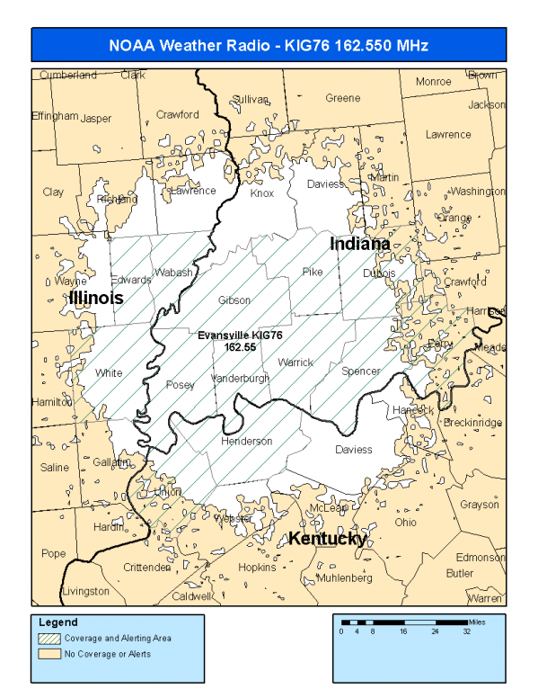
This radio station is licensed by the FCC to The National Weather Service for Evansville, IN and serving the following areas:


Edwards County, IL Wabash County, IL White County, IL Dubois County, IN Gibson County, IN Perry County, IN Pike County, IN Posey County, IN Spencer County, IN Vanderburgh County, IN Warrick County, IN Henderson County, KY Union County, KY

We are not aware of any currently available online broadcast streams for this station.
Antenna Location: LAT: 38.1809916 ~ LON: -87.4868265
Loading Main Map for ...
NOAA Weather Radio KIG76 S.A.M.E. Code(s):
S.A.M.E.CountyState
017047EdwardsIL
017185WabashIL
017193WhiteIL
018037DuboisIN
018051GibsonIN
018123PerryIN
018125PikeIN
018129PoseyIN
018147SpencerIN
018163VanderburghIN
018173WarrickIN
021101HendersonKY
021225UnionKY
KIG76 Coverage Map
Service Frequency Power Latitide Longitude
NOAA Weather RadioWeather162.550 MHz1000 Watts38.1809916-87.4868265

[ Top of Page ]

"KIG76 (162.550) Evansville, IN - NOAA Weather Radio"

Radio Station:

Email: support@ | facebook | twitter
Policies: Terms & Conditions (EULA) | Privacy Policy | Cookies | DMCA

Copyright © 2025 Radio Station Network (RSN)

Station Image
Status
0:00
10
7
5
31Hz
62Hz
125kHz
250kHz
500kHz
1kHz
2kHz
4kHz
8kHz
15kHz
VOL.