NOAA Weather Radio Station

WXJ71 162.475 Peoria, IL

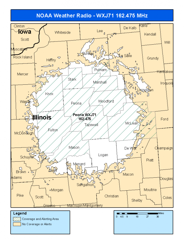
This radio station is licensed by the FCC to The National Weather Service for Peoria, IL and serving the following areas:


Fulton County, IL Knox County, IL Marshall County, IL Mason County, IL McLean County, IL Peoria County, IL Putnam County, IL Stark County, IL Tazewell County, IL Woodford County, IL


WXJ71 can be heard online using the Radio Station Net Player.
Stream Status
Verifying WXJ71 Audio Stream ...
Antenna Location: LAT: 40.6290993 ~ LON: -89.5701599
Loading Main Map for ...
NOAA Weather Radio WXJ71 S.A.M.E. Code(s):
S.A.M.E.CountyState
017057FultonIL
017095KnoxIL
017123MarshallIL
017125MasonIL
017113McLeanIL
017143PeoriaIL
017155PutnamIL
017175StarkIL
017179TazewellIL
017203WoodfordIL
WXJ71 Coverage Map
Service Frequency Power Latitide Longitude
NOAA Weather RadioWeather162.475 MHz1000 Watts40.6290993-89.5701599

[ Top of Page ]

"WXJ71 (162.475) Peoria, IL - NOAA Weather Radio"

Radio Station:

Email: support@ | facebook | twitter
Policies: Terms & Conditions (EULA) | Privacy Policy | Cookies | DMCA

Copyright © 2025 Radio Station Network (RSN)

Station Image
Status
0:00
10
7
5
31Hz
62Hz
125kHz
250kHz
500kHz
1kHz
2kHz
4kHz
8kHz
15kHz
VOL.